
Weather means the current state and forecast within 10 days, the term climatic conditions means the long-term weather regime for at least 30 years (Lapin, 2016). Climateis a long-term weather regime, which refers to the course of meteorological elements and phenomena (air temperature, cloud, air pressure and humidity, wind direction and speed, etc.) for several decades. It is conditioned by the energy balance of the circulation of the atmosphere, the nature of the active surface, but also by human intervention.
The weather pattern is not constant, but changes over the years. For each climate, there is a typical weather, i. we can talk about normal weather. By normal weather we mean a development that is consistent with the long-term weather regime. Heavy thunderstorms, floods, hail or high temperatures are normal if they do not occur too often. In practice, 50% of cases closest to the long-term average are considered normal weather conditions. Weather cases that occur more rarely than every 50 years are considered extraordinary. Weather normal is generally calculated from observations made over a minimum period of 30 years (Lapin 2004).
The climate character is influenced by various factors, which are referred to as climatic factors (climatic factors). Individual factors cannot be clearly defined because their effects overlap, i. they do not appear separately. The climatic factors include sunlight (its intensity is determined by latitude, altitude and cloudiness of the region), physical-geographical conditions (especially relief segmentation, altitude, latitude), atmospheric circulation (the prevailing type of air flow, which affects the relief segmentation, coast of large water bodies, friction of air on the earth‘s surface) and man (especially growth of CO2 and other gases in the atmosphere).
The basic meteorological elements include:

(Picture source: http://studysoaring.stlsoar.org/fcstrpts.htm)
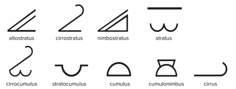
The clouds are divided in shape into two main categories: cumulus clouds (from Latin cumulus = accumulation) and stratified clouds (from Latin stratus = layer).
Further, we can divide them in terms of vertical height. The low group (located up to 2 km) consists of stratus, nimbostratus, cumulus and stratocumulus.

Cumulus clouds are thick, white and inflated, resembling cotton balls. They occur either as separate clouds or printed on each other. While cumulus clouds are associated with good weather, stratus clouds are dark gray, low, evenly stratified or covering the entire sky and are usually associated with rain).

The group of medium clouds is located between 2–5 km and is marked with the prefix alto (altostratus and altocumulus). High clouds are located above 5 km in the cold troposphere and are marked with the prefix cirro or cirrus. At this altitude, the water freezes, so the clouds are almost always composed of ice crystals. These clouds are tuft and often transparent (cirrus, cirrostatus and cirrocumulus). Aircraft capacitors are formed at this altitude. Vertical clouds have strong ascending currents and are formed at a wide altitude and include cumulonimbus, which are very large, elevated dark clouds usually associated with heavy rainfall and storms.
Atmospheric air pressure – it is a measure of the force exerted by the mass of the atmosphere on the earth‘s surface at a given location, and its magnitude depends on the amount of air lying above the surface. That is why the air pressure decreases with increasing altitude, ie. the highest pressure is just above the earth‘s surface. The basic unit of pressure is Pascal (pressure exerted by 1 N (newton) per m²). In meteorology it is reported in hectopascals [hPa]. However, we can also see the designation in millibars [mbar] or in Torro (1 torr ~ 4/3 hPa). The standard atmospheric pressure is 1013.25 hPa (at 0 meters above sea level and 0 °C). Air pressure is measured using barometers. If the pressure rises (mostly at lower altitudes) together with the temperature, we can expect nice weather – consequently the pressure rises will slow down or eventually stop. On the contrary, if the pressure drops rapidly (or in the long term), we can expect the arrival of rain or storms. As the altitude rises, the air density also changes. The air is densest at the surface of the Earth. The air molecules are constantly moving and their movement varies with temperature. As the temperature rises, the movement of the molecules increases. Increased movement also causes greater separation of molecules. The opposite is true when cooling. For this reason, the substances increase in volume on heating and decrease in cooling.
Air humidity – is a general term that refers to the water vapor content of air. We distinguish between absolute and relative humidity. Absolute humidity is the actual amount of water vapor per volume of air. Relative humidity indicates the ratio between the actual and maximum possible air saturation at a given temperature in the atmosphere. Within the air humidity we also distinguish so-called a dew point that represents the temperature at which the air is maximally saturated with water vapor, with a relative humidity of 100%. If the temperature drops below the dew point, water vapor condensation (i.e., liquefaction) occurs.
Wind and its speed – the term wind means the air flow that occurs between two places with different air pressure (from higher to lower pressure). When describing the wind, it is necessary to recognize two basic variables, namely its speed and direction. The wind speed is measured using an anemometer and the wind direction is measured with a meteorological windmill at a height of 10m above the earth‘s surface (measured in m/s or km/h). For example, the northeast wind is blowing south from the northeast. The wind direction is also usually indicated by an angle of 0° (north) to 360° (north).
In the wind we also distinguish the so-called. wind impact, which is the maximum wind speed, which lasts at least 3 seconds and which occurs within a 3-minute interval.
The above mentioned meteorological elements can also be expressed by means of schematic marks, which make it easier to record the observed weather:

From the above it is clear that the climate is shaped and influenced mainly by the energy coming from the Sun. Many other factors such as climate change are involved in this process (climate formation). water, the earth‘s surface, the shape of the earth, animals, etc. We can say that the nature of the climate results from the interaction of all the above-mentioned parts of the Earth‘s climate system, forming the earth‘s surface.